Strangford Lough

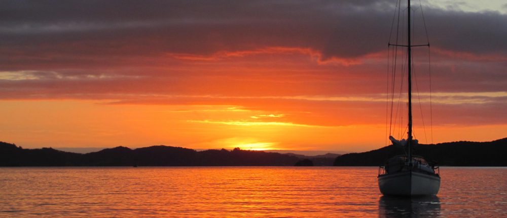
After lunch the next day, we set off to catch the north flowing tide to take us to Strangford Lough five miles up the coast. We can only enter the Lough on a rising tide, when the water is flowing in from the sea through the Narrows to the Lough proper. Apparently, something like 400 million gallons of water pass in and out through the Narrows twice a day. Currents can reach 7 knots in each direction and we would have no chance of making any headway against that – instead, we would be carried back out to sea.

Entering Strangford Lough – the current starts to flow faster.

We begin to be swept along by the current, imperceptibly at first, but eventually at such a speed that trees, houses, churches, fields, and cars on the far shore pass quickly out of our sight. The water boils angrily as it encounters some underwater obstruction or cross current, but we are swept mercilessly onwards. It is out of our control now – we are committed to sail up the Lough – going back is no longer an option. There is nothing we can do except steer and avoid any obstacles by staying as much as possible in the middle of the stream. Our speed increases to 6 knots, then 7, 8, 9 and eventually reaches 11.4 knots. That is the fastest that Ruby Tuesday has been on the whole trip!

Top speed – 11.4 knots!

We pass a peculiar-looking structure in the middle of the river looking like a bird hanging its wings out to dry. We learn later it was a tidal stream generator to generate electricity from the powerful currents. At one point, the current sweeps us towards it, and we have to take evasive action not to hit it, sweeping past with only metres to spare. Apparently some yachts have hit it, and have lost their masts as a result. We shudder as we think of what could have happened.

The SeaGen construction.

As we approach the small village of Strangford on the western side and its counterpart Portaferry on the eastern side, the ferry connecting the two begins to cross in our path. We slow down as best as we can, cutting the engine, but it makes not much difference, and we slide somehow to its stern, avoiding it more through luck than good management. Strangford Lough is proving to be a bit of a slalom! In the excitement of passing the ferry, the current almost takes us beyond the entrance to the small harbour, but we slew ungracefully into an eddy out of the main stream, pause for a moment to regain our aplomb, and cruise slowly to the pontoon, looking around surreptitiously to check if anyone saw our ungainly manoeuvres. Nobody seems to have, and we are able to resume our pretence of knowing what we are doing. We tie up to the pontoon and explore the village.

Trying to avoid the ferry between Strangford and Portaferry ferry at 10 knots!

Tied up to the pontoon in Strangford village.

We decide to eat at the Cuan Inn in the village square. It seems that the cast of the Game of Thrones stayed here when they were filming some episodes at the local Castle Ward, about a mile from here. In the series it is known as Winterfell Castle. While we are waiting for our food to arrive, the proprietor, Peter, comes over and introduces himself, sits down and begins to tell us of some of the cast, what they liked to eat, and of what is was like filming some of the scenes. He shows us the ornately carved wooden door that was made especially for the series and now occupies pride of place near the main bar. We decide that the Northern Irish are nothing if not chatty!

The Game of Thrones door, Cuan Inn, Strangford.

We stumble back to Ruby Tuesday, only to find that we are nearly hemmed in by the ferry, which has stopped for the night. We can just about squeeze out if we need to, so it is lucky we don’t have any plans to go anywhere else for the rest of the evening. The ferry winks at Ruby Tuesday as if to say that she will be safe with her.

Hemmed in for the night by the ferry!

The next morning, we take the self-same ferry across to Portaferry, and visit the local museum. As we look a giant map of the village as it was in 1790, we are approached by the museum director.

“He changed his name, you know”, he says. ”So that he could marry the woman he loved.”

“Who was that?”, I say.

“Andrew Savage”, he responds. “The local land owner. The Savages are one of the old families of the area and used to own the village. House is up behind the village. Andrew fell in love with a girl, but her father said that he didn’t want his daughter marrying a savage, so he changed it to Nugent. He went from being a savage to a new gent, see?”. He laughs. We laugh politely too. We wonder how many times he has repeated that one.

Map of Portaferry in 1790.

He tells us that the place used to be quite a haven for smugglers. Around 1700, the British government slapped taxes on tea, coffee, whiskey, tobacco, spices, chinaware, cotton and many other items. Many of these items were imported from France via the Isle of Man into Portaferry where duty had to be paid, but the numerous small bays around Strangford Lough were ideal for smugglers to off load goods from the ships before they came into harbour, leaving only some of the cargo to arrive legally. The illegal goods would then make their way inland concealed in baskets of fish. The problem for the excise men was that most of the local people didn’t see why they should have to pay duty for life’s luxuries, and actually supported the smugglers. Even the local gentry saw it as a good investment. Stiffer and stiffer penalties were introduced, from fines, transportation to the colonies, and even death. Rewards were paid to informers. Despite all this, smuggling flourished, and it was only the formation of the Coastguard in 1822 that brought it under control. Will such smuggling start again because of Brexit, I wonder?

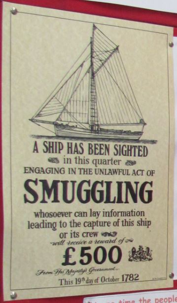
Wanted for smuggling. Not Ruby Tuesday!

The next exhibit is of the SeaGen project that we nearly ran into in the Narrows the day before. It seems that it was a commercial electricity generator for some years, but was sold to another company and is now being dismantled. Now we could see how the whole thing worked – giant propellers like wind turbines could be raised and lowered at will into the current. Apparently, it was very successful and could produce 1.2 MW – enough power to supply all the households in both Strangford and Portaferry. The director can’t understand why it is being dismantled as it could have kept on being productive.

The SeaGen tidal power generator.

However, it seems as if other devices are being tested, including one that looks like a model aeroplane on a tether which apparently is much more efficient, so perhaps Strangford Lough will continue to play a role in Northern Ireland’s renewable energy programme. We hope so.

A new tidal power generator.

We wander back through the village. A group of cyclists just off the ferry are enjoying refreshments at a café before they continue. Bikers astride their Harley-Davidson’s roar noisily through the narrow streets as they continue northwards. A family visit the derelict 16th century tower-house castle, another of the Savage family properties, before climbing back into their car and driving on. A dilapidated shop advertising ‘Needful Things’ has long since closed. Several other shops are also boarded up. There is a general air of decline about the village, as though it has seen better times, a place now that people don’t go to but just pass through instead. It makes us feel sad.

Portaferry Castle.

No longer needed?

Over to Ireland

We leave Douglas the next morning aiming to pass the Calf of Man as the tide turns so that we can catch the north-west flowing current to give us a helping hand across the Irish Sea. It is cold and clammy, with fog hanging low across the island obscuring everything above a few metres. Apparently this is what the Isle of Man is like most of the time. A solitary seal munches its breakfast as we motor slowly out of the harbour and turn southwards.

Seal munching his breakfast, Douglas harbour.

It is dead calm with no wind, and we have to motor down to Langness Point on the south-east corner of the island. Around the point, the eastwards tide is still running, and we need to battle against the current to make any headway. We tell ourselves that it will be all worth it when we catch the north-westwards current across to Ireland in an hour’s time. Sometimes one has to make sacrifices in the near term so that there are greater benefits later! As if to cheer us up, just at that moment the clouds clear and the sun comes out.

We eventually reach the Calf of Man off the south-west corner. The name of the island conjures up an image in my mind of a newly born calf lying next to its mother, which, as the name derives from the Old Norse kalfr meaning an island lying next to a larger one, is not so far-fetched. Perched on the Calf are two disused lighthouses, now used as a bird observatories. Off to our port side is the Chicken Rock lighthouse built in 1875 warning ships of the dangers of straying too close. The area certainly didn’t do too badly for lighthouses.

Bird observatory on the Calf of Man.

Chicken Rocks lighthouse.

A wind picks up from the north-west and we hoist the sails, and skim along on a close reach at a good speed. Before long, the Isle of Man disappears from view and we are alone on the sea. Three gannets fly over, their yellow heads bright in the sunlight. We relax and lapse into our own thoughts.

Suddenly a patrol boat appears on our port side out of nowhere. A blue flag with yellow stars flutters from its stern. It draws alongside, and over a loudspeaker, one of the crew asks us to stop. I am puzzled. This is the third time that we have been intercepted now – the first at Lulworth Firing Range, and the second at Castlemain Firing Range in South Wales. But surely the middle of the Irish Sea can’t be a firing range? We can’t even see land. Perhaps we have blundered into a submarine training area?

We furl the sails and come to a halt. One of the patrol vessel’s crew throws a line across and asks us to tie it to a cleat, and then clambers on board.

“Passports, please”, he says. The accent is Irish. Our passports are below in the cabin. The First Mate goes down to find them. “Where is your destination?”, he asks me. I tell him we are heading for Ardglass in Northern Ireland.

“Do you have anything to declare?”, he asks. “No”, I say, “Just personal items. Laptops, a tablet, phones, that kind of thing.”

“Do you mind if I have a look?”, he says. Before I can answer, he is climbing down the companionway into the saloon area. He pokes around, opening cupboards, looking behind our books, checking our food store. We feel that he is intruding on our private space, but we say nothing. He asks us to lift the floorboards, where we have more tins of food.

“Are these only for your own consumption?”, he asks. I nod.

“There is too much here for just two people”, he says. “I am afraid I am going to have to charge you duty.”

I protest that we are sailing around the UK and that we need a lot of provisions for when we anchor in way out places, but he is adamant. “It’s what you voted for after all”, he says.

Is this the shape of things to come?

I am awoken from my reverie by the First Mate bringing a cup of tea. I had been imagining what it would be like if a new customs border between the European Union and mainland Britain had been created in the middle of the Irish Sea as a result of Brexit. Since an agreement could not be reached, the UK has crashed out of the EU with no deal, and trade is now under WTO rules. Because no-one wants a hard border to be recreated between Eire and Northern Ireland, it has been decided to allow the latter to stay in the customs union with the EU, and to have the customs border in the Irish Sea. Because everything is much cheaper in the UK due to the removal of most labour and environmental regulations, duty is now payable on all goods entering Ireland so as not to undercut EU industries. The Irish Sea is patrolled by fast vessels to prevent smuggling of cheap goods. Fanciful, I know, but no more ludicrous than many of the other contortions brought about by Brexit. The cup of tea cheers me up.

We are suddenly joined by a pod of dolphins swimming alongside us and leaping out of the water in front of us in sheer exuberance. We sit on the foredeck and watch these beautiful creatures showing off their skills to us, almost as if they are trying to impress us. “Don’t worry about borders”, they seem to say, “Look at us – we swim wherever we want. We are free. It is only you humans that want to put up walls and barriers between yourselves. Come with us and learn the true ways of the earth.” Are we really more intelligent than them?, I wonder.

Dolphins in the Irish Sea.

(Click here to see a video of the dolphins.)

The coast of Ireland appears. To the south we see the Mountains of Mourne sweeping down to the sea. The rays of the setting sun strike the clouds and light them up with streaks of silver, while the lowlands radiate a soft golden glow. It is beautiful.

The Mourne Mountains, Northern Ireland.

We arrive at Ardglass just on low water. In the twilight, we follow the leading lights into the tiny marina where a few other boats are tied up. A cheerful American helps us tie up next to his boat – he and his friend are heading off southwards early the next morning and they promise not to wake us.

Approaching Ardglass.

Ardglass marina.

Peel, Ramsey and Laxey

“Donkeys can carry about 340 lbs for 15 hours a day”, a voice behind us says. “I should know, I used to command a donkey team in Nepal.”

My knowledge of donkeys is limited, but I am fairly sure that taking commands is not one of their strong points. I wonder facetiously what language the owner of the voice talked to his donkeys in? Ass-amese, perhaps?

The First Mate and I are on a bus on the way to Peel on the west coast of the Isle of Man. We have bought Day Travel cards which entitle us to ‘hop-on-hop-off’ bus travel for a day, and plan to do the round trip of Peel, Ramsey and Laxey.

“Yes”, the donkey commander continues. “I had a team of ten men and their donkeys that we used to ferry supplies from one hill station to another. Lovely country, Nepal.”

I am dying to turn around and see who the donkey commander is, but don’t want to appear rude. I surreptitiously look in the driver’s convex rear view mirror and just make out the reflections of two rather military-looking gentlemen in cloth caps in the seat behind us. They seem to have only met each other on the bus, but know about half of the British Army in common between them, and spend the rest of the bus trip discussing the achievements, faults and failings of them all. Or so it seems to us. The donkey commander seems to be higher ranking than the other, who spends most of his time agreeing with what the commander says. We decide to call them the Commander and Corporal.

Getting off the bus in Peel. The Commander and Corporal follow.

We arrive in Peel, and disembark near the harbour. The Commander and Corporal also get out and go their own ways. It is raining, so we take shelter in the House of Manannan museum in the old railway station. Manannan was a mythical sea god of the Celts who ferried dead souls to the Otherworld in a chariot pulled by his trusty steed Enbarr, and may have given his name to the Isle of Mann. The museum has life-size reconstructions and numerous videos covering the Celtic, Viking and modern traditions, reminiscent of the Jorvik museum in York. Next door, there is an exhibition on cartoons by Phil Wood which keep us amused until the rain stops.

The House of Manannan.

We walk along East Quay past the marina until we come to the lock gates, which as chance would have it are just opening to let two or three boats out. Beyond is St Patrick’s Isle with the impressive Peel Castle situated on it. The original castle was built in wood by the Viking, Magnus Barefoot, in the 11th century, but was added to over the years using the local red sandstone. There is even a cathedral built within it. The grave of the so-called Pagan Lady whose spectacular necklace of precious stones and cache of silver coins we had seen in the Manx Museum in Douglas were also found in a graveyard within the castle.

Peel Castle.

We have lunch in the Marine Hotel on the beach front, making sure that we sample the local Bushey beer, before catching the bus to take us on to our next port of call, Ramsey, on the east side of the island. On the way, we talk to a man from London who builds and plays pipe organs, and who has been coming to the Isle of Man every summer for the last 40 years because he likes it so much. He is organising a concert in Douglas in a week’s time and invites us to come. He is not allowed to charge for the performance, but donations are welcome and go to a charity of his choice. We promise to come if we are still in Douglas then.

On the bus to Ramsey.

It is pouring with rain as we arrive in Ramsey, and we make a dash to the bus shelter. The town is supposed to have the sunniest climate and the lowest rainfall on the whole island, but someone has forgotten to tell the weather gods today.

While waiting for the rain to stop, we have coffee in the appropriately named Conrod’s Coffee Shop in Ramsey, with its TT motorcycle theme. On the bus, we had passed several stands for spectators at strategic positions along the road, and we had noticed several shops with motorcycles in the front window, even if they weren’t actually selling them. The race, which is held in May and June every year, is a bit of an orgy for petrol-heads, and involves closing all roads on the track to the public for two weeks, and is regarded at the most dangerous motorsport event in the world. It would have been interesting to see it, but apparently the Isle is overrun with bikers at the time and it is not easy to get around.

Racing bike in shop window.

The rain eases off, and we explore the town. Like the other towns on Man, Ramsey has its origins in Viking times and gets its name from the Old Norse words meaning ‘river of wild garlic’. The Viking heritage is evident as we explore the town, particularly a fine sculpture of two Viking kings playing chess. One is the legendary King Orry and the other his son, King Olaf. Orry must have been another one who liked Mann, so much so that he kept coming back time and again to try and take over the island. On the first two occasions, he was sent packing by the local Manxmen, but managed to beat them on the third attempt, and became the island’s ruler. I think that if I was a Manxman, I would prefer holiday makers giving organ recitals!

Kings Orry and Olaf playing chess.

We get off the bus in Laxey, or ‘Salmon River’ in Old Norse. We don’t see any salmon, but the main attractions are two large water wheels used to pump water out of the lead and zinc mines that flourished during the 19th century. One wheel, the Lady Isabella, is supposed to be the largest functioning waterwheel in the world. The mine itself extracted mostly lead, but also zinc, silver, copper and iron, but eventually the amount of ore taken out reduced, and together with problems of flooding that the giant wheel couldn’t cope with, the mine became uneconomic to run and it closed.

The Lady Isabella water wheel in Laxey.

Interestingly, the three-legged symbol of the Isle of Man, the triskelion, is reversed on the wheel – apparently this was a mistake and there were plans to correct it at one point, but nobody got around to it. The Manx are quite proud of their symbol – one story put about is that whichever way it is thrown, it will always end up on its feet, illustrating the resilience of the Manx nation. Another more prosaic explanation is that one leg is to flee from Ireland, the second is to kick Scotland, and the third to kneel to England. Whatever the meaning nowadays, it is an ancient Neolithic symbol, and has been found in tombs in Ireland dating back to more than 3000 B.C., and in Malta as far back as 5000 B.C. A similar symbol is on the flag of Sicily.

The Manx Electric Railway train draws into Laxey station.

We sit and have an ice cream in the warm sunshine. At that moment, there is a toot, and a small train appears from around the corner and draws to a stop at the little station nearby. It is the narrow-gauge electric railway that runs from Douglas up to Ramsey. We consider taking it back to Douglas, but at that moment, the bus arrives and we climb on that instead. It goes much the same route, after all.


Douglas

“Would Madam and Sir like to see our tea selection?”, the waiter with a man-bun says, appearing from the shadows and thrusting a menu in front of us. The accent sounds Italian.

We are in a swish tea shop in Douglas. The room is dark, with green marble wallpaper, and all around us are portraits of famous people, many in military uniforms. A box of cigars lies open on a small delicately carved wooden table. I wonder momentarily if we have stumbled into the office of a banana republic dictator.

“Ooooh, turmeric latte”, says the First Mate after a quick scan. “We have to some of that – it’s fantastic. And it’s good for you – it has lots of antioxidants.”

I am not sure if I need any more antioxidants, but I may have been getting too much oxygen in all the sea air I have been breathing lately, so perhaps I do. The waiter with the man-bun looks slightly perplexed. I suspect he was looking forward to showing off his knowledge of the world’s teas.

“Garçon. Deux turmeric lattes, s’il vous plâit”, I say. Moi, I can do pretension too. I realise too late I have said it in French rather than Italian. Not that I know any Italian anyway. The waiter with the man-bun looks even more perplexed.

The two turmeric lattes arrive, lighting up the room.

“Urrrrgh. I don’t like this very much”, says the First Mate after a sip.

“I thought that you said it was fantastic and good for you?”, I say.

“I read it somewhere”, she says. “Can you drink it?”

I actually quite like it, and polish off both glasses with gusto while the First Mate wades into an extravagant-looking cake.

The tumeric lattes arrive.

We are exploring Douglas after the gale has subsided. It is a curious place – while there is obviously money here judging from some of the houses tucked away and cars being driven around, there is also a feeling that it has seen better days. Early in the twentieth century, it was the ‘place to be’ holiday resort for well-to-do folk from northern England, who would disembark from steamers in their droves to enjoy the summer there. Apparently, it was known as ‘Naples of the North’, and was reputed to have a thousand boarding houses and dancing halls along the promenade.

The promenade in Douglas.

Today the promenade is more-or-less deserted apart from an occasional jogger. Despite all the space available, an old lady pulling a shopping trolley cuts in front of me, nearly tripping me up. She stops, and looks intently out at the small castle marking St Mary’s Isle, a dangerous reef that is submerged at high water. We try to imagine what takes her interest so much.

St Mary’s Isle in Douglas harbour.

We find the museum and spend the next couple of hours there. As museums go, it is a good one, and gives us a comprehensive overview of the island and its history. Settled by Celtic people, and later influenced strongly by the Vikings, the Isle of Man has somehow managed to remain independent from the rest of the UK, albeit with the status of a Crown Dependency managing its own internal affairs but with the UK taking responsibility for its foreign policy and defence. It even has its own Parliament, the Tynwald, dating from Viking times, which it claims to be the longest continuously functioning parliament in the world.

Viking display, Manx Museum, Douglas.

The wildlife section is very well done, and we are able to clarify the names of several birds we have seen but not been able to identify. We see the famous four-horned Loaghtan sheep, native to the island, and whose meat is regarded as a delicacy.

Loaghtan sheep, Manx Museum.

That evening, a Harbour Control man knocks on the window. He apologises profusely for not coming sooner to see us to make sure that we are all OK and to bring the forms we have to fill out, but it was the weekend and he had the in-laws to stay. We don’t mind, and invite him in from the drizzle just starting. We make him a cup of coffee.

He is from Manchester originally, but has lived in the Isle of Man for 13 years. His previous job was a steward in the merchant navy, but he got fed up with all the travel and decided to settle down. “Eventually the glamour of travelling the world wears off”, he says. He loves living here as it is much more relaxed, and cheaper. Taxes are lower, and he can afford a house in Douglas and cycles to work, something he could never do in Manchester.

We mention the words ‘tax haven’, and his brow furrows. “People don’t like that term here”, he tells us. “It’s true that back in the 1960s and 70s it was actively promoted as that, but the UK Government didn’t like the idea of the wealthy hiding all their money here and not paying taxes on the mainland, so they have tidied up their act here now. They prefer to call it a ‘low tax area’.”

We nod sagely, wondering what the difference is.

Changing the subject, he tells us that the ferry that supplies the island, Ben My Chree, had suffered ‘catastrophic failure’ on the Saturday, and has had to cancel all sailings until it is fixed. He isn’t sure exactly what catastrophic failure means in this case, but that is what someone had told him. Perhaps some problems with the engines.

The last time it had happened it had been out of commission for a week or so, and the shops had run out of supplies from the UK. People had started panic buying to stockpile food, causing even more shortages. They were trying to keep it quiet this time to avoid that. I wonder why he is telling us, especially as the First Mate mutters something about getting to Tesco first thing in the morning.

The Ben My Chree.

That night, I lie awake wondering if the turmeric latte will turn my hair orange and people will call me Donald. In the morning, I go to the heads and look in the mirror. My hair seems normal, but I am sure that my pee is yellower than yesterday. Hopefully it will work its way through.


The Isle of Man

In the morning, the weather forecast tells us that a gale will arrive the next day. Holyhead harbour is a bit exposed (in fact the marina was destroyed by the Beast from the East storm in early 2018), so we reckon that we will be better off finding shelter in Douglas on the Isle of Man. The only thing is that we will need to leave pretty much straight away to get there in time.

I take Peter and Joanne over to the shore in the little dinghy. No one is around, but the cleaning lady has promised to be there by 0800 to open the sailing club so they can retrieve their luggage. They have a taxi arranged to take them to the station for the train to London. We say our goodbyes and I head back to Ruby Tuesday. It seems strange to return to a boat with just the two of us. It has been good to see them.

We set off as soon as we have the dinghy loaded on the back. The wind has gone around to the south, so it is directly behind us. It is blowing at about 12 knots, so we goosewing and make a good speed.

On the way to the Isle of Man.

The First Mate brings out a cup of tea. I reflect on the last few months since we started our voyage, and how quickly the time has flown. I find my perception of that time has also changed – rather than a series of chunks ordered by the demands of a working day, it is more of a flow – hours glide by, and days merge into one another. Time has not disappeared, but it has settled into a pattern governed more by the earth’s great rhythms – day and night, the flood and ebb of tides, the seasons. In between, the everyday jobs of route planning, sailing, and keeping the boat tidy and in working order keep us occupied. The hourly filling out of the logbook when we are sailing, and the keeping of a diary do provide some structure, but it is easy to forget these, and I find myself amazed sometimes when several days have gone by since the last entry in the diary. We do seem to be less stressed and the sense of urgency is disappearing – if we don’t do something today, it can always be done tomorrow. And we feel better for it.

It makes me wonder if modern civilisation has gone too far in its perception of time and how it must be filled. When we were working, there was relentless pressure to make every moment count – to be doing something, producing something, deciding something, meeting someone. But what did it all achieve? There was so little time to ponder and reflect on the great mysteries of life and appreciate the world around us. Should we all take time out, just to go with the flow? Would we be happier, more fulfilled, more creative, and (dare I say it) more productive in the long run?

Suddenly, out of the haze, I see a large yacht passing in front of us. I check the radar and AIS (Automatic Identification System) and see that it is doing 11 knots. That’s fast, if it is correct! Then I see another one on the screen, then two more, some way behind. It is too hazy to see the actual boats at first, but they are there somewhere. Then the second one appears and passes a few hundred metres in front of us. The crew see us and wave frantically to us. It suddenly dawns on us that we have stumbled into the middle of a race, but this is no ordinary one – it is the Clipper Around the World Race that started in 2017 and these boats are now racing to the finishing line in Liverpool, perhaps an hour away. This is what our neighbour in Aberystwyth marina was heading to see.

Seattle – one of the boats in the Clipper Round the World Race.

An hour or so later, we hear whoops of joy over Channel 16 on the VHF. The voice is unmistakably female and antipodean. We learn later that it is Wendy Tuck, an Australian, who has won the race. The boat we have seen, Seattle, is the second placed, skippered by a Nikki Henderson, a British woman. I tell the First Mate that there is hope for her yet. She ignores me.

We arrive in Douglas around 1800. Entry into the marina is via a lock gate that only opens two hours either side of high tide, and a road bridge also has to be raised. We are told by Harbour Control that the gates will open at 2215 and we can wait until then at the temporary pontoon in the outer harbour rafted up to one of the boats already there. The boat we tie up alongside is called Lady. We think there is a certain symmetry there – a Lady visiting the Isle of Man. Boom, boom!

Approaching Douglas, Isle of Man.

We cook dinner and relax. Another boat draws up alongside and rafts up to us. It has a dog, a brown spaniel. The dog has been sick. The skipper explains that they have come from Conwy in Wales. It seems they rowed out in a small dinghy to their boat moored in the harbour to do some work on it, but couldn’t get back to shore because it was too rough, and decided on the spur of the moment to go to the Isle of Man instead, as one does. There are a lot of questions I feel need asking on this one, not least on why anyone would do that with an imminent gale warning, but I decide life is too short. The spaniel looks at me sorrowfully. “Don’t ask”, she seems to say.

At 2215, there is a burst of life. The gates have opened, and we form an orderly queue to proceed up to the marina. It is dark, and we follow the lights of the boat in front. We have been allocated a berth at the top of a side arm, which suits us fine. We can see street lights, shops and restaurants, and realise that we are close to the centre of town. We tie up the mooring lines and turn in.

Douglas harbour at night.

The gale arrives in the early morning. There is an eerie calm beforehand, then the wind begins to blow. We are relatively sheltered in the marina, but the windspeed indicator at the top of the mast reads 50 knots at one point. Then the rain starts. We snuggle deeper into our beds. There is something immensely satisfying about being tucked up warmly and safely while the elements rage around us.

Tucked up safely and soundly in Douglas marina.


Holyhead

“Yes, we have a spare visitors’ mooring for you”, the lady from the sailing club says over the VHF in response to our request as we round Holy Island. “The launch will be out to show you where it is. You’ll know the launch from its colour. Pink. You can’t miss it.”

I try to imagine a pink boat, but give up. I think it is called cognitive dissonance, but in any case I have other things to think about. We are coming into Holyhead harbour, and I need to work out how to get out of the way of a massive ferry just off our port quarter. As we pass the breakwater protecting the harbour, sure enough there is the pink launch. It actually looks quite good.

The pink launch.

The pink launch draws alongside, and we are directed by the launch man to a yellow buoy next to a Moody 42. A woman on the Moody eyes us suspiciously.

Our crew manage to catch the yellow buoy with the boathook and haul up the thick rope. Usually mooring buoys have a lighter slip line to catch, but for some reason this one doesn’t seem to. They struggle to lift the heavy line, and eventually manage to slip the end loop over the forward cleat.

“You’d be better off putting it over the bow roller first”, says the pink launch man. I wonder to myself why he didn’t tell us that at the beginning. The crew unloop the thick rope again and try to thread it through the bow roller.

“You need to bring the boat a bit further forward to take the strain”, says pink launch man to me.

“You need to reverse a bit”, calls out the suspicious lady on the Moody.

“Can you go sideways a bit?”, says the First Mate.

I decide to do nothing. Eventually the rope is pushed through the bow roller and looped over the cleat. We relax. The suspicious lady on the Moody disappears down below. Pink launch man draws alongside and tells us how much we have to pay for the night. It’s reasonable, considering he will also act as a water taxi, taking us to and from the shore up until 10 pm for no extra charge.

Going ashore in the pink launch.

We eat that evening in the sailing club. Later, Peter and Joanne take their suitcases over from Ruby Tuesday on the pink launch to leave them in the club house, and they make arrangements to collect them in the morning. They are catching the train for London at 0900, but as the pink launch doesn’t start until 0900, I will have to take them across in our little dinghy in the morning. It makes it easier if their suitcases are already ashore.

The moon rises over the harbour while we sit on deck and have our last drink together. Tomorrow it is supposed to be a ‘blood moon’ with the earth eclipsing the light from the sun. We make a mental note to see it if we can.

Moon rising over Holyhead harbour.

Porth Dinllaen

We leave Pwllheli at 1230 so that we can arrive at Bardsey Sound at slack water at 1630 and take advantage of the north flowing tidal stream beyond that. A few other boats seem to have the same idea, and for a while we form an orderly procession as we proceed down St Tudwal’s Roads and sail between St Tudwal’s Islands. I read later that St Tudwal was a monk from Brittany who retired to one of these islands to become a hermit. The remains of his monastery are still on one of the islands.

Leaving Pwllheli on St Tudwal’s Roads.

We pass Porth Ceiriad and then the broad sweeping bay of Porth Neigwl, and Bardsey Island comes into view. Porth Neigwl translates as Hell’s Mouth, and we wonder what terrible events must have happened for it to earn such a name. All seems tranquil at the moment though, so much so that the wind dies right off and we have to motor to reach Bardsey Sound in time for slack water.

Approaching Bardsey Island.

We drift slowly through the Sound, carried by the current just on the turn. Two other boats follow us. On our port side, we pass Bardsey Island, or the Island of Currents, which has been an important religious site since St Cadfen built a monastery there around 500 A.D. There seems to be something about the islands off the Lleyn Peninsula that is conducive to religious contemplation more than some of the other islands we have seen on this voyage. In medieval times, pilgrims would come from far and wide to worship there, catching a boat at Aberdaron on the mainland and braving the often turbulent waters of Bardsey Sound to reach the island. Apparently three pilgrimages to Bardsey were the same value as one to Rome! Through the binoculars we see the Celtic cross commemorating the 20,000 saints that are reputed to be buried on the island. It is even claimed that King Arthur is buried there. It would have been interesting to stop, but we must press on.

Once around the point, the wind, such as it is, comes directly from behind us, so we rig the sails to goose-wing. There is so little force, however, that the sails barely fill and we are carried along at the majestic speed of one-and-a-half knots, mostly the effect of the tidal current. The only consolation is that the other two boats following us are doing the same speed. One, called Charisma, is also goose-winging.

Trying to catch the wind.

We fill the time reading, each in our own world. I find my favourite spot again in the sun on the foredeck.

I think of the many pilgrims that had made their way to Bardsey Island. What had made them do it? Were they just mindlessly following tradition in some massive groupthink, or did they find what they were seeking, or a bit of both? And was it the journey or the destination that provided the eventual fulfilment? I suspect for the pilgrims to Bardsey Island that it was the latter; it was where they were heading for that was more important than the getting there, although perhaps the rigours of the journey were an important part of the process in preparing them for the destination.

For ourselves, it is the journey that is more important than the destination, at least for the moment. We do have a physical destination in that we aim to be back in Scotland by the end of the summer, but within that we decide on the spur of the moment where and when we want to go, how long we want to stay in each place, and what we want to see and experience there. At the moment we see our fulfilment coming from not actually having a destination, but keeping ourselves open for seeing new places, meeting new people, and having new experiences and ideas. From that, fresh insights may gel and become the destination in themselves. I decide that until then we are travellers more than pilgrims. But not tourists, I hope wryly.

Out of the corner of my eye, I see another boat between us and the coast gradually overtaking us. It is Charisma. I wonder how she has suddenly managed to find a little bit more energy than us – perhaps the tidal stream is a fraction of a knot faster closer in to shore. No matter. I rejoin the others and put on the kettle for a cup of tea.

Drifting slowly in the tidal current along the Lleyn Peninsula.

We arrive in Porth Dinllaen around 1930 and find a place to anchor opposite the small village of Morfa Nefyn. Charisma is already there. We cook dinner and sit and watch the last of the sun’s rays reflecting off the white-washed houses.

Porth Dinllaen.

Pwllheli

The next morning is wet and misty, with visibility poor. High water is at 0700, so to clear the bar we have to leave then. Seeing the green buoys through the drizzle and mist is a challenge as the mist completely disorients us, but by following the track of the GPS we had made the night before, we finally reach the red and white buoy marking the river entrance. Now safely out past the bar, we decide to anchor and have breakfast, hoping that the mist and rain might clear.

Our track in and out of Aberdyfi harbour. Note the shifting of the channel at the river mouth.

Sure enough, an hour later, the rain stops, the mist disappears, and the sun peeks out from between the clouds. Welsh weather is nothing if it doesn’t change at the blink of an eyelid. Living in Wales during my university days had taught me that. The wind is from the south, so we hoist the sails and head north, this time to the narrow channels that take us through Sarn-y-Bwch and Sarn Badrig (St Patrick’s Causeway), two more glacial moraines similar to Sarn Cynfelyn we had encountered just outside Aberystwyth. According to the legend, they were also causeways leading to the kingdom of Cantre’r Gwaelod.

Once safely through them, we set a course for Pwllheli, our destination for the night. The wind is still from the south, on our beam, and we have some good sailing across Tremadog Bay with the mountains of Snowdonia in the background. Up until now, Peter has been a little bit disappointed that he has not yet seen more mountains in Wales, but this makes him happy. One of them even looks like a volcano with its covering of cloud.

The mountains of Snowdonia from Tremadog Bay.

An active volcano in Wales??

As we arrive at the marina, we pass a rower heading in the same direction. We ask her where she has come from to which she replies Shrewsbury. With Shrewsbury well inland, we think either we misheard or she is joking, but we find out later that she is indeed from there. Her name is Kelda Wood and she is planning to row single-handed across the Atlantic in her small boat Stormy Petrel to raise funding for her charity helping young people to regain their confidence after a life-changing injury. She herself suffered a leg injury while horse riding when young. It’s a big challenge to row that distance but we wish her all the best and hope she makes it. Brave woman!

Kelda Wood and her Stormy Petrel.

That evening, we take a walk around Pwllheli, but it is late and nothing is happening except for a fish jumping out of the footpath. It happens all the time, so we content ourselves instead with an ice-cream before heading back to Ruby Tuesday.

Fish trying to escape the concrete jungle.

Aberdyfi

We leave Aberystwyth just before high water the next day, and head out to sea to avoid the shallow parts of the underwater shingle spit Sarn Cynfelyn that stretches out several miles into Cardigan Bay. Legend has it that this was a causeway that led out to the kingdom of Cantre’r Gwaelod in the middle of Cardigan Bay, which was flooded when one of the princes of the kingdom during a drunken stupor accidentally forgot to close the sluice gates of one of the dykes protecting the kingdom. The remains of a submerged forest which was supposed to be part of the kingdom can still be seen on Borth beach just to the north of the spit. Apparently if you listen carefully on a stormy night, you can still hear the kingdom’s cathedral bells ringing, warning sailors to keep away. It’s a great story, with parallels with other Celtic flood myths, but geologists tell us that it is more likely to be moraines of the glaciers that once flowed down the associated valleys during the Ice Age.

Cardigan Bay showing the shingle spits and our route to Aberdyfi.

About three miles out to sea, there is a deeper gap through the spit called the Main Channel, which we take before turning northwards for Aberdyfi, where we have decided to stop for the night. With a fresh westerly breeze, we have a good sail along the coast up to the mouth of the Dyfi River marked by a large white and red buoy. We call the Aberdyfi harbourmaster, who tells us that the course of the river has changed, and that we should follow the green starboard marker buoys into the harbour where we can tie up to one of the visitors’ buoys. The only problem is that the positions of the green buoys bear no relationship to the charts we have, at least for the first bit.

At that moment, the wind strengthens and it starts to rain, so we decide to put our trust in the harbourmaster knowing what he is talking about and head for the first green buoy, keeping a watchful eye on the depth sounder. With the onshore breeze and the waves breaking on the bar, it won’t be an easy matter to turn around again if we have to, but luckily we manage to stay in the new channel even though we have only a metre of water below the keel in one or two places. The green buoys are quite far apart, so it is not always easy to spot the next one. However, eventually we rejoin the old channel, find the visitor’s buoy, and manage to tie up to it. And none too soon, as the heavens open fully at this point, forcing us to retire to the cabin to dry out and warm up. The salmon we have for dinner that night goes down a treat!

Cooking the dinner after mooring in Aberdyfi.

Aberystwyth

Three feet hit the white bar simultaneously in time-honoured tradition.

We are in Aberystwyth, my old university town. Back then it had been a ritual for anyone walking along the promenade to ‘kick the bar’ of the white railings when they reached the northern end near Constitution Hill. There are a number of theories about the origins of the tradition, but the one that I like best was that Edward VII had visited the town when he was the Prince of Wales, and while walking along the promenade had put his feet up on the bar to retie his shoelaces. The people of the town had continued the tradition as a mark of respect to their prince.

‘Kicking the bar’ on Aberystwyth’s promenade.

We had left Fishguard around lunchtime the day before and had caught the tidal current northwards. A light breeze had allowed us to hoist the sails to give Peter a chance to hone his sailing skills. Coming into Cardigan, we were amazed at the rock formations and the way that they had been rolled up into a near perfect circle. What forces had caused that, we wondered?

Interesting rock formations near Cardigan.

As we were in no specific hurry, we had decided to anchor in Cardigan and enjoy the sunset with a glass of wine before cooking dinner. An initial attempt on the northern side under a brightly-lit hotel had proved to be too exposed to the slight swell coming in from the south-west, so we had motored across to the south shore near the old lifeboat station and anchored there. Protected from the south, it had been much smoother. We had thought briefly about visiting Cardigan town, but the wide shallow bay had meant that we would have a long way to take the little dinghy before reaching shore, so we decided to stay on board, cook dinner, and retire early.

We had left at 0800 the next morning and continued northwards. The sun had come out, and the wind had dropped to a mere puff. The sea had been like a mirror, disturbed only by Ruby Tuesday’s wake. From time to time, we had encountered flocks of black guillemots on the water enjoying the peace and warmth and dispersing only as we neared them to settle a little further away. The light had been ethereal, bathing the sea and sky in a soft glow. Only the billowing clouds of the weak cold front on the horizon we had been warned about on the forecast had reminded us that it would not always be so peaceful.

The cold front on the horizon.

I lie on the foredeck in the sun and ponder the ideas in Peter Reason’s book on the relationship between ourselves and nature. At one level, it is not difficult to surmise why this division might have occurred in the first place – nature can be dangerous and life-threatening, and once humans developed an awareness that there is a distinction between life and death and that the latter could be caused by things in the natural world, then it became an enemy, first to be avoided, then to be controlled to meet human needs. I wonder if prehistoric humans conceived of themselves as being different. No one knows for sure, but the cave paintings they left behind would suggest that they worshipped some of the animals around the and therefore saw them as being higher and stronger than themselves. Later we realise that we are cleverer than most animals and we worship other natural objects that we think are stronger – the sun and the moon. The division between nature on earth and humans has begun.

A gannet flaps stiffly over the boat, turning its yellow head this way and that in search of an unsuspecting meal. It reminds me briefly of the annual harvest of guga, or young gannets, by the men of Ness in the Outer Hebrides, carrying on an age-old tradition. Modern civilisation has lost this direct link, and indeed condemns it, but Reason argues that to reconnect to nature, we need to start a new conversation with it. I think back flippantly to my light-hearted chat with my bird friends at Beaulieu River, and am relieved that at least I hadn’t thought of eating them. Perhaps there is hope yet. But I wonder if we can really reconnect again, or whether we are forever separated by our intellect and self-awareness? We can say the words, but does anything really change in our minds? Or is nature just a human construct, able to be changed over time like many more of our worldviews?

We are nearing Aberystwyth now. I awake from my reverie and calculate whether we can enter the harbour yet. There is a sand bar to avoid and we have been warned by the harbour master that the river is quite silted up, so we must enter two hours either side of high water and must carefully follow the transit marks of a west cardinal buoy and a yellow pole behind. It is still three hours to high water, and so we must wait another hour before there is enough depth for our draft. We anchor for lunch just outside the harbour and wait.

Aberystwyth.

Eventually we enter without any trouble and tie up to our pontoon alongside another couple who are heading north to watch the end of the Round the World Clipper race in Liverpool. He had been one of the crew on a previous leg.

We set off for the town to see the sights. I explain that before we do anything else, we have to complete the tradition of ‘kicking the bar’, so first up is the promenade. Duty done, we wander back to the pier and have an ice cream in the hot sun.

On the Aberystwyth Pier.

I point out the places I used to frequent, and talk about the people I used to know and the things we got up to. We even find one of the student houses I used to stay in –it is in a state of disrepair, but looks like it is being refurbished from the scaffolding around it.

One of the houses I used to live in.

Further on, we come across the chippie that sustained us when we couldn’t be bothered to cook. It had been an enjoyable stage of my life, an awakening of self, so it is a time of nostalgia for me now – 40 years is a long time ago, and a lot of water has flowed under the Rheidol bridge since then.

The Central Chippie.

Our sightseeing done, we traipse our way wearily back from the town and sit and have a drink watching the sun go down over Cardigan Bay.

Sunset over Aberystwyth marina.